
Hazard Mitigation Plans
The essential steps of hazard mitigation – hazard identification, vulnerability analysis, and creating a hazard mitigation strategy – are addressed in the creation of the local hazard mitigation plan. The Illinois State Water Survey (ISWS) collaborates with Illinois counties, regional planning commissions, and the University of Illinois Extension to create and update local hazard mitigation plans.
Structures at Flood Risk (SAFR)
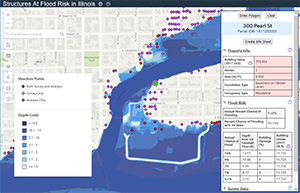
SAFR is the product of collaboration between the Illinois Department of Natural Resources (IDNR) and the Illinois State Water Survey (ISWS). It contains data about structures in Illinois and their flood risk. SAFR is password-protected. The intended audiences are state and local officials and agency staff; in particular, floodplain managers, mitigation officers, and city planners.
Buyouts Database
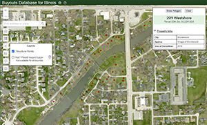
The Illinois Buyouts Database is the product of collaboration between the Illinois Department of Natural Resources (IDNR) and the Illinois State Water Survey (ISWS). It contains data about structures in Illinois that have been mitigated through acquisition. The Buyouts Database web map is password-protected. The intended audiences are state and local officials and agency staff; in particular, floodplain managers, mitigation officers, and city planners.
What is Mitigation?
