ISWS is providing building footprints for every county in Illinois for download in shapefile format. Building footprints represent the perimeter outline of each building, but these outlines can only roughly represent the buildings. Sometimes one single polygon may include many buildings that are close to each other.
In 2018, Microsoft released building footprint polygon geometries in all 50 US States in GeoJSON format. In 2021, a second vintage was released, with nearly half of Illinois having been rerun with newer imagery. The building footprints were generated by training computer vision algorithms to recognize building geometries on aerial imagery of the USA. More information can be found on github. ISWS is making these available in shapefile format for all Illinois counties. Additionally, a Vector Tile implementation of the data is hosted by Esri.
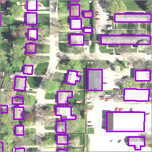
Also in 2018, for a select number of counties in Illinois, ISWS extracted building footprints from LiDAR data in LAS format and converted these into polygons. As part of the extraction process, a squaring function was performed to produce an approximation of the roof outlines of buildings by squaring the traced building outlines. Thus, the extraction detected rectangular buildings very effectively, but buildings with other shapes may not be extracted as their real shapes.
How does the data compare for counties where both building footprint types are available? In short, the ISWS derived footprints are more numerous than the 2018 vintage Microsoft data. One reason for this is the LiDAR files for each county included areas close to, but outside the county boundary, and building footprints for these areas are included in the shapefile. An additional reason may be that the LiDAR used by ISWS was more recently acquired than the imagery used by Microsoft in creating footprints. A more detailed explanation of the comparison process is found in this report.
 Download
Click the "SWS" or "MS" link next to the county of interest to download the shapefile created from LiDAR (SWS) or Microsoft (MS). Please see our disclaimer.