FEMA Flood Insurance Rate Maps, Studies, and Database Products
The Illinois State Water Survey provides preliminary and pending Flood Insurance Rate Maps (FIRMs), Studies, and Database Products on this web site. Effective Flood Insurance Rate Maps are posted at the Federal Emergency Management Agency (FEMA) Map Service Center web site.
For communities with effective digital FIRMs, the data can also be viewed using FEMA's National Flood Hazard Layer (NFHL) viewer. The NFHL dataset represents the current effective flood data for the county. It is a compilation of effective FIRM databases and Letters of Map Revision (LOMRs). The NFHL is updated as studies go effective. More information is available at National Flood Hazard Layer | FEMA.gov.
Video Overview – IllinoisFloodMaps.org: Resources By County
This 6–minute video is an overview of what can be found in the Resources By County section of the IllinoisFloodMaps.org website.
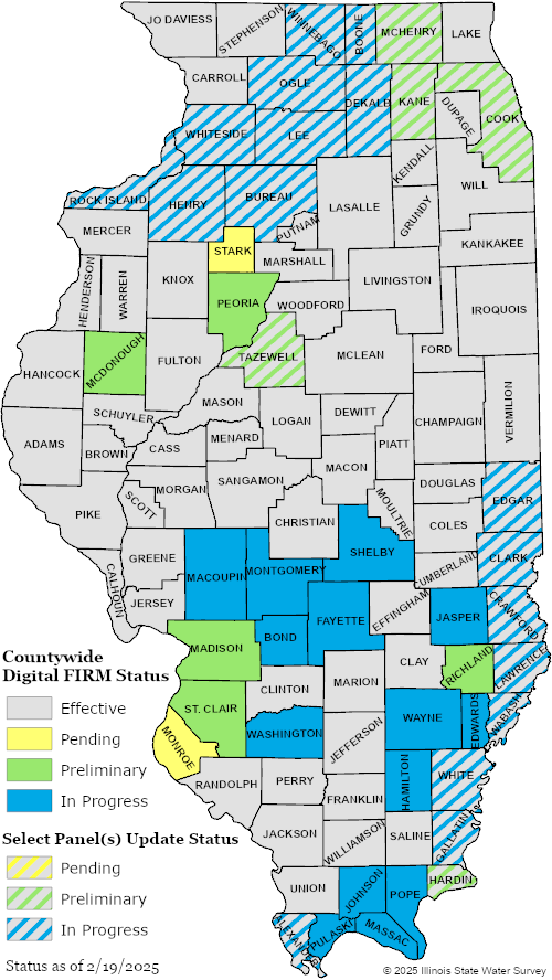
To view the products and resources available for a county, click on the county in the map above.
Solid color fill of blue, green, or yellow indicates that all panels in a county are under revision;
Countywide Map Revision.
Diagonal lines of blue, green, or yellow indicate a subset of county panels are under revision;
Limited Panel Physical Map Revision (PMR).
BLUE = In Progress data and products
GREEN = Preliminary data and products
YELLOW = Pending data and products
GREY = Effective data and products
Preliminary data are for review and guidance purposes only. Preliminary data may include new or revised Flood Insurance Rate Maps (FIRM), Flood Insurance Study (FIS) reports, and FIRM Databases. By viewing preliminary data and maps, the user acknowledges that the information provided is preliminary and subject to change. Preliminary data are not final and are presented as the best information available at this time. Additionally, preliminary data cannot be used to rate flood insurance policies or enforce the Federal mandatory purchase requirement. Preliminary data will be removed from this web site once pending data are available.
Pending data are for early awareness of upcoming changes to regulatory flood map information. Pending data may include new or revised Flood Insurance Rate Maps (FIRM), Flood Insurance Study (FIS) reports, and FIRM Databases. During the six-months before effective, the flood hazard data and associated products have a status of pending, as communities must adopt or amend their floodplain management ordinance to reflect the new or updated flood hazard data prior to the effective date. Until the data becomes effective it should not be used to rate flood insurance policies or enforce the Federal mandatory purchase requirement. Pending data will be removed from this web site once effective data are available.
Please see our disclaimer.
